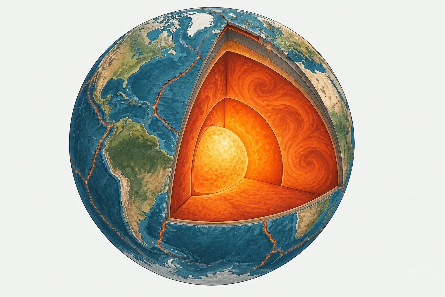
Earth’s outer shell
Earth is built in layers: a thin crust, a thick rocky mantle, and a metal core. Plate tectonics is about the top two layers, and in particular about how strong or weak the rock is at different depths.
Lithosphere and asthenosphere
The outermost layer, the lithosphere, is cold and rigid. It includes the crust and the top part of the mantle, and it is broken into large pieces called tectonic plates. Oceanic lithosphere is up to about 100 km thick. Continental lithosphere is thicker, and beneath the oldest parts of continents it can extend much deeper.
Below the lithosphere lies the asthenosphere. It is still solid rock, but it is hot enough to flow very slowly over long periods, like warm wax. This weak layer lets the rigid plates above it move. Plates are not floating on liquid rock. They glide over solid rock that behaves like a very thick fluid over millions of years.
Oceanic and continental crust
Every plate carries crust on its top surface, and there are two kinds.
Oceanic crust is thin, about 7 km, and made of dark, dense volcanic rock such as basalt and gabbro. It forms at mid-ocean ridges and is destroyed at subduction zones, so it never gets very old: the oldest ocean floor is roughly 180 million years old.
Continental crust is much thicker, around 35 km on average and up to about 70 km under the Himalaya and Tibet. It is made of lighter rocks rich in silica, such as granite. Because it is buoyant, it resists sinking into the mantle, so continental crust survives for billions of years. Some rocks in northern Canada are about 4 billion years old.
Most plates carry both kinds of crust. The North American Plate includes the continent of North America and the western half of the North Atlantic seafloor. The Pacific Plate is almost all oceanic, and it covers about 20.5% of Earth’s surface by itself.
Plate edges are not coastlines
Because plates carry both kinds of crust, plate boundaries rarely follow the edges of continents. The east coast of the United States and the west coast of Africa are passive margins: the continent and the neighboring ocean floor belong to the same plate and move together, so these coasts have few large earthquakes and no active volcanoes. The west coast of South America is an active margin, where the edge of the continent is also a plate boundary, and it has some of the most powerful earthquakes and tallest volcanoes on Earth. Whether a coast is active or passive tells you a lot about its earthquake risk. Check any country on its page, such as Chile or Brazil, to see which plates it sits on.
What drives plate motion
Earth’s interior is hot, from heat left over from the planet’s formation and from the decay of radioactive elements. That heat slowly escapes through the mantle, which circulates in a pattern called mantle convection. Plates are the cold top layer of this system. Three forces stand out.
Slab pull
At a subduction zone, an old oceanic plate is colder and denser than the mantle beneath it, so it sinks. The sinking slab pulls the rest of the plate along behind it, like a tablecloth sliding off a table. Most geophysicists regard slab pull as the strongest force driving plates.
The PB2002 data supports this. Plates with long subducting edges move fastest relative to their neighbors: the Pacific Plate averages about 7.3 cm per year along its boundaries, the Nazca Plate about 7.9 cm per year and the Cocos Plate about 7.0 cm per year. Plates with almost no sinking slab attached move slowly: the African Plate averages about 1.8 cm per year and the Eurasian Plate about 2.0 cm per year. Across all subduction zones in PB2002, the average relative speed is about 6.2 cm per year, higher than for any other type of boundary.
Ridge push
Mid-ocean ridges stand higher than the old ocean floor around them, because young lithosphere is hot and expanded. Gravity makes the plates slide gently down and away from that high ground. This ridge push is real but generally weaker than slab pull.
Mantle flow
The mantle beneath a plate can drag on its base, either helping or resisting motion. Plumes of hot rock rising from deep in the mantle can also form hotspots, such as Hawaii and Iceland, and may help start rifts. Scientists still debate how strongly mantle flow drives plates, compared with plates driving the flow beneath them.
How fast plates move
Plates move a few centimeters per year, about as fast as fingernails grow. That sounds slow, but over a million years a plate moving 5 cm per year travels 50 km. Over the 200 million years since Pangaea began to break up, such motion has opened the entire Atlantic Ocean.
Speeds on this site come from the PB2002 model. They are relative speeds, measured between neighboring plates along their shared boundaries. The fastest relative motion is at the Tonga Trench, where the Pacific Plate and the Tonga Plate converge at up to about 26 cm per year. The Mid-Atlantic Ridge between North America and Eurasia opens at only about 1.5 cm per year on average, and the East African Rift at about 0.3 cm per year. Each plate’s page in the plate directory lists its average and maximum speeds.
How many plates there are
Most textbooks list seven major plates: the Pacific, North American, Eurasian, African, Antarctic, Indo-Australian and South American plates. Several minor plates are usually added, such as the Nazca, Cocos, Caribbean, Arabian, Philippine Sea, Juan de Fuca and Scotia plates.
The PB2002 model, published by Peter Bird in 2003 and used for our maps, defines 52 plates. It treats the Indian and Australian plates as separate plates joined by a broad zone of deformation, and it adds dozens of small microplates in complex regions such as the south-west Pacific and Indonesia. Some of its plates, including the Okhotsk, Amur, Yangtze, Sunda and Somali plates, are still debated. Other models use fewer plates, such as the MORVEL model with 25, and some recent studies map even more small blocks. The plate directory lists all 52 by size.
How scientists measure plate motion
GPS and space geodesy
Today plate motion is measured directly. GPS receivers fixed to bedrock record their positions to within a few millimeters, and after several years of data the drift of each station shows how its plate is moving. Other space techniques, such as radio telescopes timing distant quasars and lasers bounced off satellites, confirm the results. These measurements show the plates moving now, year by year.
Magnetic stripes on the seafloor
The ocean floor records plate motion over millions of years. As new crust cools at a mid-ocean ridge, it locks in the direction of Earth’s magnetic field. The field reverses from time to time, so the seafloor carries a pattern of magnetic stripes parallel to the ridge, mirrored on each side. Geologists date the reversals, measure how far each stripe lies from the ridge, and work out how fast the plates have separated. Recognition of these stripes in the 1960s was a turning point in accepting plate tectonics.
Other clues
The direction of motion can be read from transform faults, which line up with the way the plates slide, and from the slip directions of earthquakes. Chains of volcanoes formed over hotspots, such as the Hawaiian Islands, show how a plate has moved over the mantle below. Models like PB2002 combine many of these measurements into one consistent picture.
To see where plates meet and what happens there, continue to plate boundaries, or explore the earthquake map and volcano map. Terms on this page are defined in the glossary.