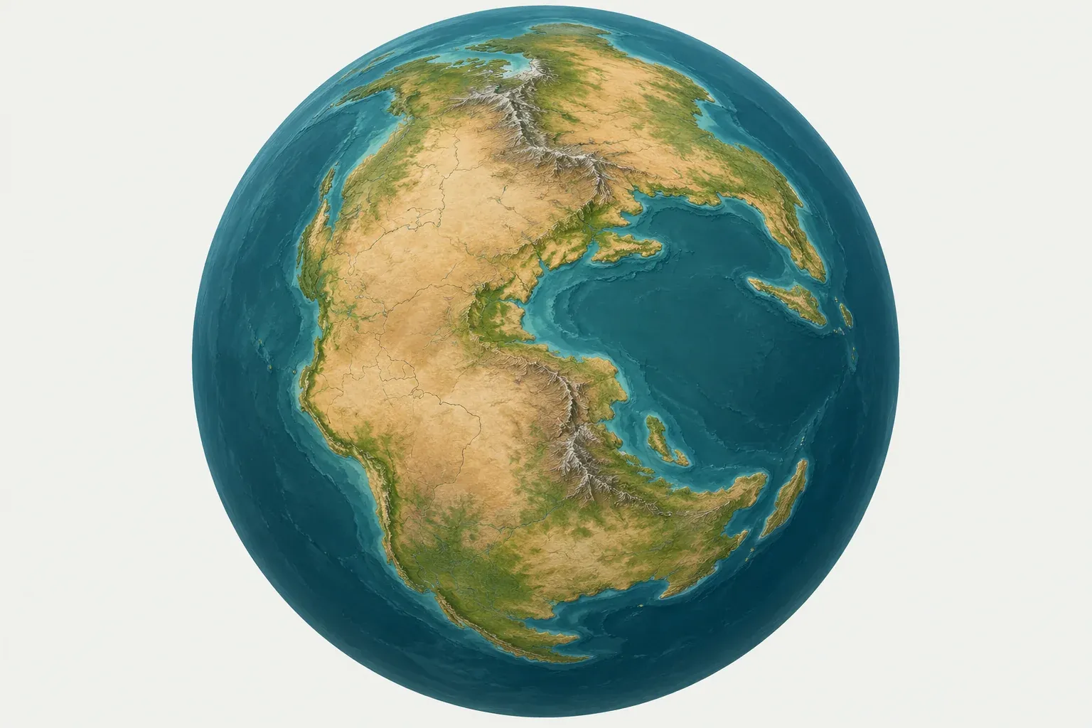
What Pangaea was
Pangaea was a supercontinent that gathered almost all of Earth’s land into a single mass. It stretched from high northern latitudes to the South Pole, shaped roughly like a letter C wrapped around an arm of ocean called the Tethys. Around it lay one vast global ocean, Panthalassa. The Pacific Ocean is the shrinking descendant of Panthalassa.
The supercontinent was largely assembled by about 335 million years ago, during the Carboniferous Period, as older continents collided. Those collisions built long mountain belts. The Appalachians of eastern North America, the old Variscan mountain belt of western and central Europe, and the Ural Mountains of Russia are worn-down remains of those collisions.
Because so much land was joined together, the interior of Pangaea was far from the sea. Large areas were hot and dry, and deserts covered much of the supercontinent during the Permian and Triassic periods. The first dinosaurs appeared on Pangaea in the Triassic, when animals could walk across what are now separate continents.
Laurasia and Gondwana
Pangaea had two main halves. The northern half, Laurasia, included what is now North America, Greenland, Europe and most of Asia. The southern half, Gondwana, included South America, Africa, Arabia, Madagascar, India, Antarctica and Australia. Gondwana was older than Pangaea. It had been a large continent long before it joined the northern landmasses.
In the language of today’s plates, Laurasia became the continental parts of the North American Plate and the Eurasian Plate. Gondwana broke into the continents of the South American Plate, African Plate, Arabian Plate, Indian Plate, Antarctic Plate and Australian Plate.
How Pangaea broke apart
Rifting begins
Pangaea began to split about 200 million years ago, near the end of the Triassic Period. Rift valleys opened between North America and north-west Africa. Huge volumes of basalt lava erupted along these rifts in what geologists call the Central Atlantic Magmatic Province. Many scientists link this volcanism to the mass extinction at the end of the Triassic.
The Atlantic opens
The rift between North America and Africa widened into the central Atlantic Ocean during the Jurassic Period. Later, in the Cretaceous Period, the South Atlantic opened as South America pulled away from Africa, like a zipper running from south to north. Last, the North Atlantic opened between Greenland and Europe, separating the final links between North America and Eurasia.
The Atlantic is still opening today along the Mid-Atlantic Ridge, a divergent boundary. The ocean as a whole widens by about 2.5 cm per year. In the PB2002 model, the South American and African plates separate at an average of about 3.2 cm per year along their shared boundary of nearly 15,000 km, while the North American and Eurasian plates separate at about 1.5 cm per year.
Gondwana breaks up
Gondwana came apart in stages. Africa and South America separated as the South Atlantic opened. India, together with Madagascar, broke away from Antarctica and Australia, and then India split from Madagascar and moved north across the Tethys Ocean. India’s collision with Asia, which began tens of millions of years ago, is still raising the Himalaya at a convergent boundary. Australia and Antarctica were the last pieces of Gondwana to separate, and Antarctica settled over the South Pole.
As these oceans opened, the old Panthalassa shrank. Its floor has been subducting around its edges ever since, and the trenches that consume it today form the Ring of Fire.
The evidence for Pangaea
Matching coastlines
The shapes of South America and Africa look as if they fit together, and people noticed this on early maps. In 1965, a computer fit by the British geophysicist Edward Bullard and colleagues showed that the match is much better at the edge of the continental shelf, the true edge of the continents, than at the present shoreline.
Fossils
Identical fossils appear on continents now separated by thousands of kilometers of ocean. Mesosaurus, a small reptile that lived in fresh water, is found in Brazil and in southern Africa, but it could not have swum across an ocean. The seed fern Glossopteris left fossil leaves in South America, Africa, India, Australia and Antarctica. The land reptiles Lystrosaurus and Cynognathus show the same pattern across the southern continents.
Matching rocks and mountain belts
Rock types, ages and structures line up across the oceans. Ancient rock regions in Brazil continue into West Africa. The folded rocks of the Appalachians match those of the Caledonides in the British Isles and Scandinavia. When the Atlantic is closed on a map, these belts join into continuous chains.
Glacial striations
About 300 million years ago, during a long ice age, glaciers covered parts of South America, Africa, India, Australia and Antarctica. They scratched grooves called striations into the bedrock beneath them. Today some of these scratches are in places near the equator, such as central India, and their directions make no sense on a modern map. When the southern continents are fitted back together into Gondwana around the South Pole, the striations point outward from a single ice sheet.
Paleomagnetism
Volcanic rocks record the direction of Earth’s magnetic field when they cool, including where the magnetic pole lay at that time. Rocks of the same age from North America and Europe point to different pole positions, which is impossible if the continents never moved. Close the Atlantic, and the two records line up. Paleomagnetic data from the seafloor, in the form of magnetic stripes on either side of mid-ocean ridges, later showed how the oceans themselves had opened.
Wegener, continental drift and plate tectonics
The German scientist Alfred Wegener proposed in 1912 that the continents had once been joined, and he set out his evidence in his book The Origin of Continents and Oceans, first published in 1915. He called the original supercontinent Pangaea. Wegener gathered the fossil, rock and climate evidence above, but he could not explain what force moved the continents. He suggested that they plowed through the ocean floor, which physicists showed was impossible. Most geologists rejected continental drift for decades.
The answer came from the ocean floor. In the 1950s and 1960s, seafloor mapping revealed mid-ocean ridges, deep trenches and symmetrical magnetic stripes. Harry Hess and others proposed seafloor spreading, and by the late 1960s these ideas had been combined into the theory of plate tectonics.
Plate tectonics differs from Wegener’s continental drift in one important way. Continents do not plow through the ocean floor. They ride as passengers on rigid plates of lithosphere that include both continental and oceanic crust. New ocean floor forms at ridges and sinks back into the mantle at subduction zones, and the continents move with the plates. Read more about how plates move and interact on the plate boundaries page.
Supercontinents before and after Pangaea
Pangaea was not the first supercontinent. Geologists recognize a supercontinent cycle, in which continents gather and disperse every few hundred million years. Rodinia, which assembled more than a billion years ago and broke apart several hundred million years before Pangaea formed, is the best studied earlier supercontinent. Pannotia, a shorter-lived grouping near the end of the Precambrian, and Columbia (also called Nuna), much older still, are proposed from more limited evidence, and their exact shapes are debated.
The continents are still moving, so most geologists expect another supercontinent to form. Several hypotheses compete. In Pangaea Proxima, the Atlantic stops widening and closes, bringing the Americas back against Europe and Africa. In Amasia, the Pacific keeps shrinking and the Arctic closes, so the Americas meet Asia near the North Pole. Other proposals combine these patterns. Most models put the next supercontinent a few hundred million years in the future, and none of them can be tested yet. The current motion of each plate is on its page in our plate directory.